
How Real-Time GPS Trackers Work

-
01GPS trackers use signals from at least four satellites to pinpoint location
-
02Real-time trackers refresh location every 1 to 10 seconds over cellular networks
-
03Trilateration uses satellite signal timing to place position within 3 to 10 meters
-
04Multi-constellation receivers combine GPS GLONASS and Galileo to cut signal dropouts
-
05GPS jammers transmit radio noise that blocks satellite signals and kills live tracking
How Real-Time GPS Trackers Work (Explained Simply & Scientifically)
Imagine your car goes missing from the parking lot. Instead of panicking, you open your tracking app and watch its live location move across the city in real time. Within minutes, you know exactly where it is, and recovery becomes possible before real damage is done.
That’s how real-time GPS tracking works. Satellites orbiting nearly 12,000 miles above Earth constantly send timing signals to your tracker. The device calculates its position through a process called trilateration, then instantly transmits that data through cellular or satellite networks to your phone or dashboard.
This is the science that turns invisible satellite data into visible movement, helping car owners, families, and fleet managers stay in control, no matter where their vehicles go.
What Is Real-Time GPS Tracking?
Real-time GPS tracking means seeing a vehicle’s location as it moves, second by second. The device continuously calculates its position using satellite signals and sends those updates to your phone or computer through the internet.
Think of it like sharing your live location on Google Maps, but instead of a person, you’re tracking a car, truck, or even a shipping container. Every few seconds, the map refreshes to show exactly where the tracker is, whether parked, moving, or idling.
This differs from passive tracking, where the device stores travel data internally and uploads it later. Real-time systems, by contrast, stream updates almost instantly, giving users actionable data when it matters most.
Most GPS trackers refresh every 1 to 10 seconds, depending on signal strength and network speed. That’s fast enough to monitor routes, detect unusual stops, or respond to emergencies in real time.
How GPS Tracking Actually Works (Step-by-Step)

Behind every moving dot on your map is a precise chain of communication between space, earth, and your device.
Each stage in this process, from satellite signal transmission to app visualization, plays a crucial role in ensuring location accuracy and real-time performance. The GPS ecosystem constantly works behind the scenes, balancing timing precision, signal strength, and network speed to deliver smooth and consistent updates to your screen.
Here’s how a GPS tracker actually works, step by step.
1. GPS Satellites (The Space Segment)

The space segment is the backbone of the entire GPS. A constellation of 31 operational satellites, managed by the U.S. Space Force, orbits Earth about 12,000 miles above the surface. These satellites circle the planet twice a day, constantly transmitting timing and position signals that GPS trackers use to pinpoint location.
Each satellite carries atomic clocks synchronized with ground control to ensure timing accuracy down to billionths of a second, crucial for calculating distance and position.
Although GPS is the U.S. system, other nations operate similar global networks known collectively as GNSS (Global Navigation Satellite Systems), including GLONASS (Russia), Galileo (Europe), and BeiDou (China). Most modern GPS trackers can read signals from multiple constellations at once, improving accuracy and reducing signal dropouts.
Satellite Generations (Blocks I to III)
GPS technology has evolved through several generations, called Blocks, each improving accuracy, durability, and signal strength:
- Block I (1978–1985): Experimental phase, 11 test satellites launched to prove the concept.
- Block II / IIA (1989–1997): First operational network enabling 24/7 coverage.
- Block IIR / IIR-M (1997–2009): Added signal redundancy and better resistance to interference.
- Block IIF (2010–2016): Introduced stronger civilian signals (L5 band) and longer design life.
- Block IIIA (2018–Present): Current generation, up to three times more accurate, featuring improved anti-jamming tech and longer lifespan.
2. Ground Stations (The Control Segment)

While satellites broadcast the signals, ground control stations ensure everything stays precise. Operated by the U.S. Space Force, this network of monitoring sites tracks satellite orbits, uploads updated navigation data, and synchronizes each satellite’s atomic clock.
These stations detect even the tiniest orbital drifts or timing errors and send correction commands to keep the entire GPS constellation accurate within a few centimeters. Without this continuous calibration, tracking data would quickly become unreliable.
In essence, the control segment acts as mission control, maintaining perfect timing, health, and positioning for every satellite in orbit.
3. GPS Receivers (The User Segment)
This is where you, or your tracking device, come in. The user segment includes all GPS-enabled receivers: vehicle trackers, smartphones, drones, and wearables.
A GPS tracker’s receiver and internal antenna capture satellite signals, measuring how long each takes to arrive. Using data from at least four satellites, the device calculates its exact position via signal triangulation.
Placement and power matter: a tracker mounted under metal surfaces or inside thick vehicle panels may struggle with reception. High-end devices often use ceramic or amplified antennas to maintain accuracy even in low-signal environments like tunnels or dense cities.
Together, satellites, ground stations, and receivers form a perfectly timed global network, turning space-based signals into real-time location data you can see on your screen.
The Science Behind GPS Trilateration

Every GPS tracker figures out where it is by using a clever bit of geometry called trilateration, not to be confused with triangulation, which uses angles. Trilateration relies purely on distance measurements from satellites orbiting Earth.
Here’s the simple version:
- Satellite 1 tells your tracker it’s somewhere on a huge invisible sphere around that satellite.
- Satellite 2 does the same, where those two spheres overlap narrows the position to a circle.
- Satellite 3 adds a third sphere, and its intersection pinpoints a single point on Earth, your tracker’s location.
To make this work, the tracker measures how long each satellite’s signal takes to arrive. Because radio signals travel at the speed of light, even a microsecond of delay translates into hundreds of meters. That’s why each satellite’s atomic clock must stay perfectly synced, and your tracker’s internal clock constantly adjusts to match.
Modern receivers often use signals from four or more satellites to improve reliability and correct for small timing errors. Under clear skies, GPS accuracy typically falls within 3–10 meters, but advanced trackers combining GPS with GLONASS or Galileo can achieve even tighter precision.
How Real-Time Tracking Becomes ‘Live’

When you watch your car icon move on a map, what you’re really seeing is a rapid exchange of data between your GPS tracker, a cloud server, and your app, all happening within seconds.
Here’s how that pipeline works:
1. Data Collection in the Device
Every real-time GPS tracker starts by figuring out where it is. Inside the device, a GPS or GNSS chipset (commonly from manufacturers like Quectel or u-blox) communicates with multiple satellites to calculate your location.
The tracker continuously measures latitude, longitude, speed, and heading, storing the coordinates temporarily before sending them out. Placement and power matter: a hidden metal box in the engine bay may weaken reception, while a roof-mounted tracker usually gets a cleaner signal.
2. Transmission to the Cloud Server
Once the tracker knows where it is, it sends that data to a cloud server using either cellular networks or satellite connections.
Most trackers use 2G, 4G LTE, or 5G SIM cards, while hybrid models combine cellular and satellite for areas without coverage. The server receives the location packets, timestamps them, and prepares them for display, often within seconds, so your app sees the movement almost instantly.
3. Visualization in the Tracking App
Finally, your location data appears in the tracking app. Here, coordinates turn into a visual map marker, route line, or speed report. Apps often include alerts for geofence breaches, route replay, and driver behavior reports.
For example, a fleet manager can watch trucks move in real-time, check a driver’s last 10 stops, or receive an instant notification if a vehicle leaves its designated area. This step turns raw satellite signals into actionable, easy-to-read information for decision-making.
How Businesses Use Real-Time GPS Tracking

Real-time GPS tracking has moved beyond personal use, businesses now rely on it to boost efficiency, cut costs, and improve accountability.
From logistics and construction to delivery and field services, GPS tracking has become a core part of modern operations, helping managers monitor assets, optimize routes, and make data-driven decisions that improve productivity and customer satisfaction.
Fleet & Asset Tracking
For businesses managing multiple vehicles or expensive equipment, GPS tracking is a game-changer. Fleet managers can monitor trucks, vans, or construction machinery in real-time, ensuring everything stays on schedule and in the right location.
Beyond just tracking, these systems help companies stay FMCSA compliant, automate reporting, and optimize dispatch for faster deliveries. With alerts for off-route movement or idle times, fleets reduce fuel costs and prevent unauthorized use, turning GPS data into actionable operational control.
Delivery, Field & Service Management
Service businesses and delivery companies use real-time GPS to provide Amazon-style live updates for clients. Drivers’ locations, estimated arrival times, and route progress are visible instantly on apps, reducing customer calls and complaints. For field teams, GPS tracking ensures technicians arrive on time, assets are efficiently routed, and service windows are met, all while giving managers visibility into daily operations for smarter decision-making.
How Families & Individuals Use GPS Trackers

GPS trackers aren’t just for fleets, they give peace of mind for families and individuals too. Parents can monitor kids’ or elderly family members’ locations in real-time, ensuring safety during school commutes, outings, or emergencies.
Pet owners use GPS collars to track wandering dogs or cats, preventing panic and loss.
For vehicle owners, personal GPS trackers help recover stolen cars quickly. Imagine getting an alert the moment your car moves unexpectedly and watching its live location until law enforcement arrives. These trackers turn worry into control, making sure the people, pets, and belongings you care about are never truly out of sight.
GPS Jammers & Security Risks

Silent. Invisible. Dangerous. A GPS jammer can erase your tracker’s location in an instant, and thieves know that.
What a jammer does
A jammer transmits radio noise on GPS frequencies so the tracker can’t hear satellites. Trackers go dark, apps show the last known location, and live recovery becomes impossible. Jammers range from cheap, handheld boxes to sophisticated vehicle-mounted units.
How to spot jamming
- Sudden loss of signal in a moving vehicle.
- Repeated “no fix” or wildly incorrect jumps on the map.
- Device reports show GPS unavailable, but cellular is still connected.
- Multiple assets in the same area lose signal at once.
If you see any of these, treat it as a real security incident, not a glitch.
How modern trackers fight back
- Multi-constellation receivers: Use GPS, GLONASS, Galileo & BeiDou to reduce single-frequency disruption.
- Multi-frequency chips: L1 & L5 reception makes jamming harder.
- Cellular watchdogs: If GPS fails but the tracker still has cell, the unit flags probable jamming.
- Dead-reckoning / sensor fusion: Accelerometers and vehicle data estimate movement when GNSS drops.
- Jamming detection alerts: Advanced platforms flag suspicious signal loss and send instant alerts to dispatch.
Practical protection steps
- Use trackers with multi-constellation, multi-frequency GNSS chips.
- Add sensor-fusion features (IMU, CAN bus, odometer) to keep rough position when GPS fails.
- Hide hardwired or tamper-proof units in hard-to-reach spots, thieves target obvious OBD plugs.
- Deploy cellular & satellite hybrid devices for remote routes.
- Monitor for anomaly patterns: grouped outages, simultaneous loss across assets, or sudden “no fix” flags.
Legal note & response
Jamming devices are often illegal in many countries. If you suspect jamming, document timestamps and locations, preserve device logs, and contact law enforcement. Avoid attempting to locate or disable a jammer yourself, that can be dangerous and unlawful.
Guard your trackers with layered tech and active monitoring. That’s how you turn a vulnerability into resilience.
Future of Real-Time GPS Tracking

Real-time GPS tracking is only getting smarter. The next wave combines AI, advanced satellite networks, and IoT to make location data faster, more precise, and predictive.
AI-Based Predictive Tracking: Modern systems don’t just show where assets are, they forecast movements. Fleet managers can anticipate delays, optimize routes before congestion hits, and even detect unusual patterns that suggest theft or misuse.
LEO Satellite Constellations: Companies like Starlink and OneWeb are deploying low-earth orbit satellites that promise near-global coverage with lower latency than traditional GPS satellites. This means even remote areas will see faster, more reliable tracking.
GNSS Modernization: GPS modernization, alongside other global navigation satellite systems (GNSS) like Galileo and GLONASS, ensures stronger signals, higher accuracy, and redundancy. Combined with AI and cloud-based analytics, this future-ready setup allows businesses and individuals to track assets, vehicles, and loved ones more efficiently than ever.
Bottom line: Real-time GPS is moving from reactive monitoring to proactive intelligence, tracking that predicts, protects, and powers smarter decisions.
Conclusion
Real-time GPS tracking isn’t just a tech upgrade, it’s peace of mind, efficiency, and protection rolled into one. Whether you’re managing a fleet, safeguarding loved ones, or keeping your valuables secure, the right tracker makes all the difference.
Explore our top GPS tracker reviews, compare features, and find the solution that fits your needs perfectly. Ready to take control? Start your tracking journey today and turn uncertainty into confidence.
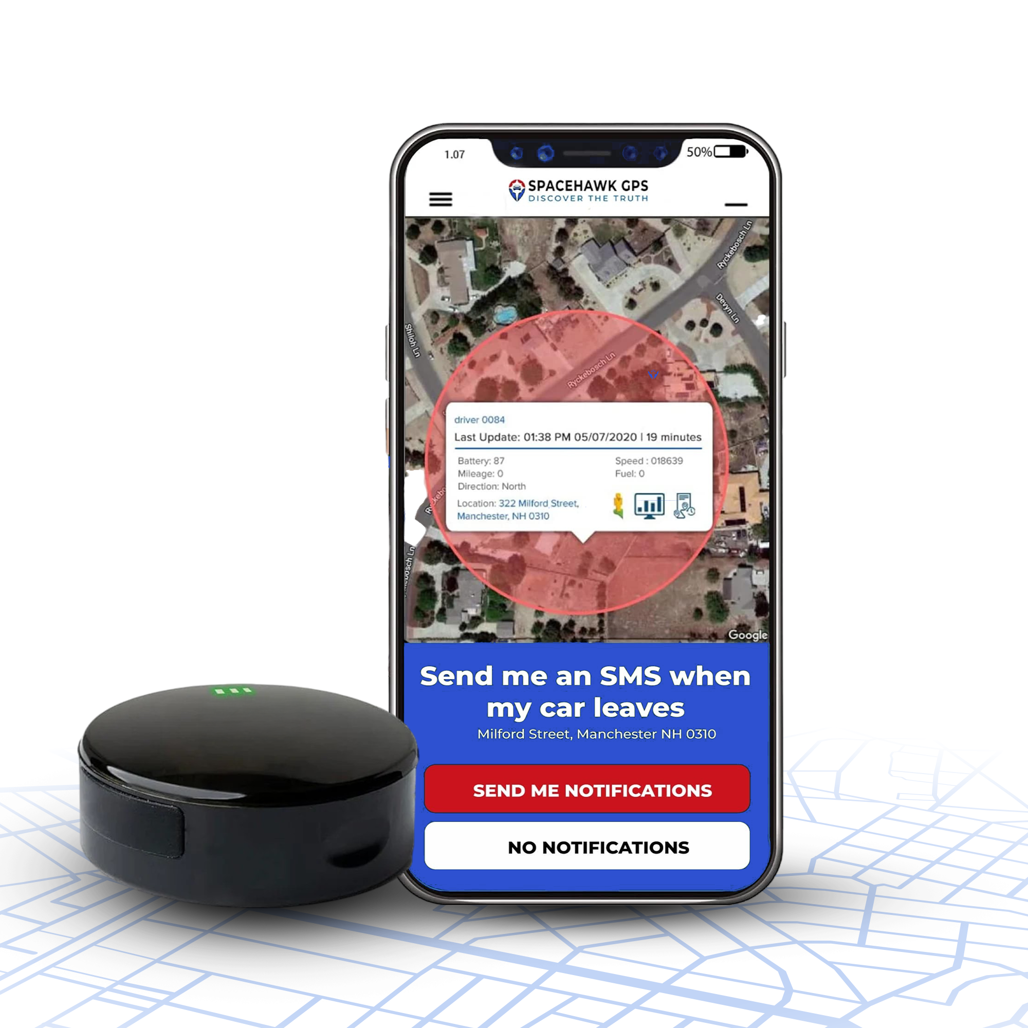
Looking for a reliable, high-performance GPS tracker?
Check out the SpaceHawk Real-Time GPS Tracker, trusted by car owners, parents, and small fleets for accurate, discreet, and 24/7 tracking.

Author Disclosure
Written by Ryan Horban, GPS Tracking Expert (15+ Years of Experience)
Over the past 15 years, I’ve helped everyone from parents and pet owners to fleet managers and small business teams choose GPS solutions that actually work.
Whether it’s tracking a car, a child, or an entire fleet, my focus is on simple, legal, and effective setups that protect what matters, without the tech headaches.
I’ve worked hands-on with real users, tested dozens of devices, and know what truly works in the real world.
👉 Connect with me on LinkedIn →
FAQs
How accurate are GPS trackers?
Most real-time GPS trackers offer accuracy of approximately 3–10 meters. Accuracy depends on satellite visibility, signal interference, and device placement. Open fields provide the best precision, while urban areas or dense forests may reduce accuracy slightly.
Most high-end GPS trackers now combine multi-constellation GNSS (GPS, Galileo, GLONASS, BeiDou) and dual-frequency technology to improve precision even in challenging environments. Some professional-grade devices, especially those used in surveying or drone mapping, can achieve centimeter-level accuracy when paired with RTK (Real-Time Kinematic) or DGPS correction systems.
Can I track someone without their consent?
No. Tracking someone’s personal vehicle without consent is illegal in most regions. GPS trackers should only be used on vehicles or assets you own or with explicit permission. Always check local laws before installation.
Do GPS trackers work without cellular service?
Some advanced trackers use satellite fallback, but most rely on 2G/4G/5G networks. Without coverage, data may log offline and upload once service resumes, but live updates won’t appear until connectivity returns.
Such as:
- Cellular-based trackers store data locally when the signal drops, then sync automatically once the network reconnects.
- Hybrid GPS + satellite models maintain tracking even in remote or oceanic regions where mobile networks fail.
- Wi-Fi and Bluetooth-assisted devices can capture short-range location data indoors or in signal-blocked areas.
This layered connectivity ensures that even when live tracking pauses, you never lose the complete movement history.
How often do GPS trackers update locations?
Real-time trackers typically update every 1–10 seconds. Faster refresh rates provide more precise movement data, essential for fleets, deliveries, or security monitoring.
Most GPS trackers let you customize the update interval based on your needs. For example, fleet managers may set a 5-second refresh rate for active routes, while personal users might choose 30-second or 1-minute intervals to save battery life. Some advanced systems even switch automatically between faster updates when moving and slower ones when stationary, balancing accuracy with power efficiency.
Can GPS trackers help reduce fuel and operating costs?
Yes. By monitoring idle time, route efficiency, and driver behavior, businesses can save 10–20% on fuel and reduce wear-and-tear, improving overall fleet ROI.
- Choosing a selection results in a full page refresh.
- Opens in a new window.
 Buy on Amazon