

5 things to know about how GPS trackers actually work
-
01
GPS needs at least three satellites for a location.
-
02
A fourth satellite adds altitude and fixes clock errors.
-
03
Tall buildings and trees can bounce GPS signals off course.
-
04
DGPS uses ground stations to correct GPS errors.
-
05
GPS signals can't penetrate water or solid ground.
How Do GPS Trackers Work?
How do GPS trackers work?
Wow, exciting question. Thanks for asking.
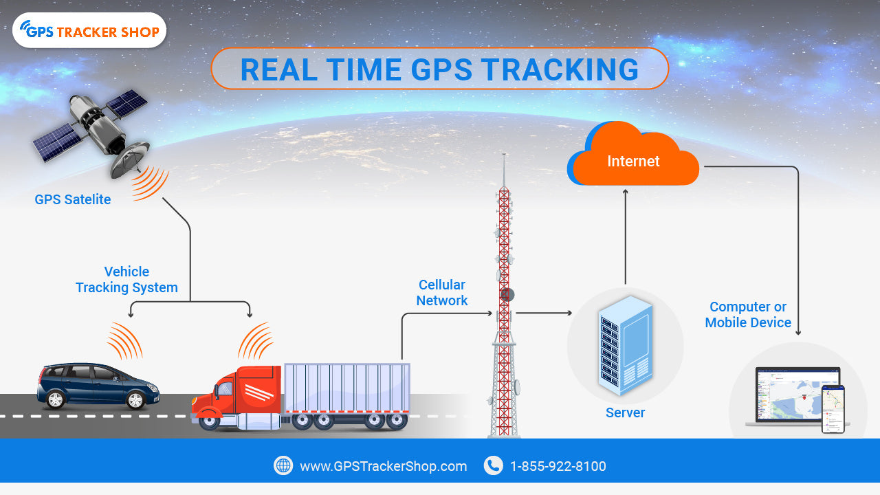
The Global Positioning System (GPS) is a satellite-based navigation system of about 30 satellites encircling the Earth that was originally designed for military use. These satellites are constantly blasting our little planet with signals.
GPS location tracking works via a process known as triangulation. Remember geometry class? Turns out it's finally paying off.
The receiver that's in your phone or car (or whatever you're tracking) must receive signals from at least three of these satellites. And, based on how long the receiver takes to pick up each signal, it's able to calculate the distance from that satellite.
Is that making sense?
In other words, the satellites are able to determine exactly where you are at all times by judging how long it takes for the signals to reach your device from the satellite. A little unsettling when you think about it — GPS satellites are watching you!
Read on to learn the science behind how the GPS network works. This is going to be fun!
In the diagram below, you can see firsthand how this works, with each circle's radius denoting its distance from a satellite. The intersection of these circles reveals the precise location of the receiver.
The Science Behind GPS Tracking

The 3 Elements Of GPS Tracking

1. Satellites
Satellites are the main component of GPS tracking.
GPS tracking relies on a constellation of satellites that form the Global Positioning System (GPS). These satellites orbit the Earth at an altitude of approximately 20,200 kilometers, and they're constantly transmitting signals that contain positioning and time data.
The GPS consists of at least 24 operational satellites. This ensures that GPS receivers can access signals from multiple satellites simultaneously, enabling more accurate positioning.
5 Fun Facts On Satellites
2. Ground Control
Ground control monitors and tracks satellite signals at all times to make sure everything is functioning properly through a network of monitoring and control stations. This network of stations makes sure the satellites are orbiting properly and transmitting signals all day.
The ground control stations also analyze satellite data and transmit any necessary corrections back to the satellites, which then incorporate these corrections into the signals they broadcast. This continuous process of monitoring and adjusting guarantees that the information provided to GPS receivers remains accurate and reliable.
5 Fun Facts On Ground Control Stations
3. Receivers
The third key element in GPS tracking is the receiver.
GPS receivers collect the signals transmitted by GPS satellites. You can find them in pretty much any device these days, especially phones and GPS tracking devices.
They pick up signals from multiple satellites and calculate the time it takes for each signal to travel from the satellite to the receiver in order to determine its precise location using a process called trilateration. This location data can then be used for various purposes, including navigation, asset tracking, and fleet management.
5 Fun Facts On GPS Receivers
The Process of Determining Location

Triangulation: A GPS Overview
Triangulation is the mathematical foundation of GPS tracking.
Let's take a look into how it works...
The satellite network, specifically the space segment of the GPS system, consists of a constellation of satellites strategically positioned around Earth.
When you use a GPS-enabled device to find your location, you must first establish a connection with these satellites.
Your device "listens" for radio signals transmitted by the satellite network.
These radio signals contain unique PRN codes identifying each satellite and a navigation message providing essential data about the satellite's health, current time, and predicted orbit.
When your device receives these signals, it uses its GNSS receiver to calculate the time of flight—the duration the signal took to travel from the satellite to the receiver. Once your device receives this signal, it now has a range of possible positions, and the next step is figuring out which one is correct…
To accurately pinpoint your location, GPS uses signals from multiple satellites. A single satellite only gives a broad area where you might be. With two satellites, this area narrows to a circle. With three satellites, you get much closer, narrowing it down to two possible points on Earth. Usually, only one of these points makes sense, as the other might be somewhere impractical—like high in the atmosphere or deep underground.
For precise triangulation, you need clear signals from several satellites with minimal interference. Clear lines of sight to satellites improve accuracy, ensuring the GPS can lock onto your exact location.

Why Three Satellite Signals Are Essential
The reason you need three satellites is that one or two alone isn't enough to find your precise location. One satellite only creates a general vicinity of where you might be. Two narrows that down to a large circle. But three lets GPS pinpoint your exact location.
With three satellite signals, that overlap narrows down to just two points. Usually, one of these points doesn't make sense (like in outer space), so the other one is your real location.
The Fourth Satellite and Improved Accuracy
So, how accurate is GPS, really?
With three satellites, GPS can give you your latitude and longitude. But when a fourth satellite comes into play, it adds altitude info, making your location even more precise by fixing any clock errors in the receiver. The more satellites your GPS connects to, the sharper your location data gets.
GPS accuracy also depends on satellite clocks staying in sync, and ground control stations constantly monitoring and adjusting satellite positions to keep everything on track. With new satellites and better tech coming, GPS will only get more accurate and reliable, giving us even better tracking in the future.
Time-Based Calculations in GPS Technology
Using GPS tracking devices might seem complex, but it's really just simple physics…that I'm sure you love (not me, I have friends).
GPS - and other similar devices like Bluetooth trackers - measures the time a signal takes to travel.
Still with me…?
Imagine you send a beam of light to a mirror and measure the time it takes to return. Knowing light's speed, you can calculate the mirror's distance. GPS tracking systems use a similar approach, but instead of mirrors, they communicate with satellite systems.
The same idea applies to GPS: when a satellite sends a signal to your GPS device, the device notes the exact moment it receives it. Since the signal travels at the speed of light, by calculating the time taken, the device determines how far away the satellite is. This is crucial for vehicle GPS trackers to provide precise location data.
For fleet tracking, such time-based calculations ensure optimized routing and enhance operational efficiency. In the world of asset trackers or vehicle tracking, these calculations are indispensable. They help reduce fuel costs and ensure fleet safety by providing real-time data.
Accuracy of GPS Trackers
GPS accuracy matters a lot since it's key to both everyday and military uses. For civilian purposes—like tracking people, cars, or lost items—GPS accuracy is usually within a few meters to tens of meters. That's plenty for things like navigating city streets, keeping tabs on loved ones, or tracking down a lost phone.
For the military, GPS needs to be way more precise, often aiming for accuracy within centimeters. The military depends on this level of detail for positioning troops, equipment, and guided weapons. In these cases, pinpoint accuracy is essential for successful missions and staying a step ahead.
Signal Multipath and Its Effects
Signal Multipath can seriously mess with GPS accuracy—it's like an echo for radio waves.
When satellites send signals to your GPS device, they ideally reach it directly. But in real life, things like tall buildings, hills, or dense trees can cause signals to bounce around before reaching your tracker. This bouncing creates "multipaths," or extra routes for the signal.
When these delayed signals hit your GPS, they can throw off your location because the GPS assumes a direct path. To fix this, GPS receivers use special antennas and algorithms to filter out these extra signals, giving you a more accurate position.
Enhancing Accuracy With DGPS
DGPS is a sophisticated technique that employs additional ground-based reference stations to address and correct any potential errors in GPS data.
The mechanics work like this: these reference stations are strategically positioned across a given area, often spaced tens of kilometers apart. They receive the same GPS signals as your tracker device and calculate the precise difference between their known locations and the GPS-derived positions. This differential information is then transmitted to GPS users, including your tracker device, in real-time.
When your tracker device receives these differential corrections, it can adjust its calculations accordingly. This correction accounts for any errors caused by atmospheric conditions, signal multipath, or other factors, significantly enhancing its accuracy. For businesses reliant on fleet tracking, DGPS can result in enhanced operational efficiency, improved fleet safety, and optimized routing, ultimately leading to cost savings and improved services.
In critical applications like medical alerts to ensure the safety of loved ones, this heightened accuracy can be a lifeline — the global navigation satellite systems you depend on stay as precise and reliable as possible, so your GPS tracker device delivers accurate information when it's needed most.

Frequently Asked Questions
Is It Possible For GPS Trackers To Work Underwater Or Underground?
No, GPS trackers rely on signals from satellites, which cannot penetrate water or solid structures effectively. Submerged underwater or buried underground, a GPS tracker simply can't pick up a satellite signal — the surrounding material blocks or severely weakens it. In these environments, alternative technologies like sonar or inertial navigation systems are superior.
How Do GPS Trackers Ensure Precise Time Synchronization For Accurate Location Calculations?
GPS trackers rely on the synchronized atomic clocks onboard each satellite to synchronize time for accurate location calculation. Each GPS satellite is equipped with precise atomic clocks that generate timing signals transmitted along with their position data. When a GPS tracker receives signals from multiple satellites, it uses the time information to calculate the distance between itself and each satellite. By precisely measuring signal travel times and leveraging synchronized satellite clocks, GPS trackers accurately determine their position on Earth's surface. This meticulous time synchronization ensures reliable and highly accurate location calculations for various applications, from navigation to tracking.
What Is The Role Of The Almanac And Ephemeris Data In GPS Tracking Accuracy?
The almanac provides approximate orbital data for satellites, aiding in rapid signal acquisition — it helps GPS trackers predict which satellites to search for based on their expected positions. Ephemeris data, in contrast, provides precise, real-time satellite positions, ensuring accuracy in the final location calculation. Together, they let GPS trackers quickly acquire signals and determine accurate positions.
 Buy on Amazon