
GPS Satellite Tracking
Key Takeaways
5 things to know about GPS satellite tracking
-
01
GPS needs signals from satellites, ground stations, and receivers.
-
02
About 24 active satellites orbit Earth transmitting GPS data.
-
03
GPS accuracy is typically within 1-2 meters.
-
04
No permits or special licenses are needed for GPS.
-
05
Accurate tracking needs signals from at least four satellites.
What Is GPS Satellite Tracking?
What the heck is GPS satellite tracking? Really!? We know satellite navigation for turn-by-turn directions while driving and GPS solutions for search and rescue operations are all awesome parts of the Global Positioning System web that have made life easier for all of us. But have you ever wondered just exactly how GPS tracking devices work? If so, this article will explain everything you need to know about satellite GPS tracking. As well as provide awesome facts and the real-world benefits of satellite GPS tech! Now, let's first dive in with some basics when it comes to GPS operations and the top choice for the best satellite GPS tracker among Amazon buyers!
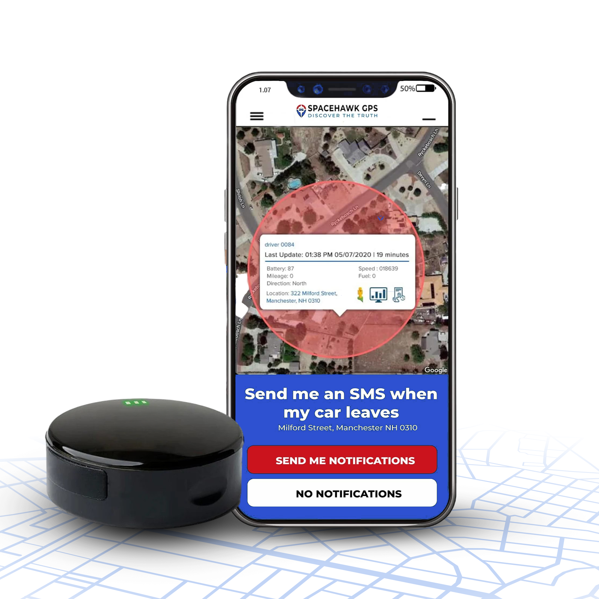
![]()
Best Satellite GPS Tracker On Amazon

According to Amazon reviews, Spot Trace X is the best overall GPS messenger and navigation device. Spot Trace is a 2-way satellite messenger that utilizes Bluetooth and realtime GPS to help protect you on your outdoor adventures. Perfect for hiking, camping, and asset tracking, Spot Trace X will allow you to communicate with the outside world via SOS protection. This means if you are ever lost or in danger, you can easily communicate with the outside world and get help. With 62% of Amazon verified buyers leaving this Global Positioning System GPS 5-stars on Amazon, Spot Trace X is easily the best GPS satellite tracker by online rating.
Spot Trace uses the Globalstar Satellite Network Coverage
![]()
What Are The 3 Basic Principles of GPS
Satellites
~24 satellites orbiting Earth, constantly transmitting position and time data.
Ground Stations
Command centers that monitor and synchronize the satellite network for accuracy.
Receivers
The device in your phone, car, or tracker that turns satellite signals into a location.
GPS Satellites
At the heart of the GPS system are satellites, often referred to as satellite vehicles. These satellites continuously orbit the Earth, transmitting essential data. For the GPS system to determine your exact location, it requires signals from at least three to four of these satellites. Their primary purpose is to send information regarding their position and the current time at regular intervals.
- Satellite Vehicles. There are approximately 24 active GPS satellites in orbit at any given time, ensuring global coverage.
- Global Coverage. With satellites spread strategically around Earth's orbit, they ensure almost every corner of the planet can receive their signals.
- Transmit Data. Each satellite constantly transmits data, allowing GPS devices to determine their exact position.
Ground Stations
Ground stations play a crucial role in keeping the satellite system running accurately. These stations monitor and manage GPS satellites, ensuring they operate correctly. When you think of them, imagine the command centers that keep the whole system synchronized. Their primary task is to maintain the satellites' accuracy and ensure the information they send to GPS receivers is precise.
- Globalstar Satellite Network & Iridium Satellite Network. These are examples of networks that connect with ground stations to keep the system synchronized.
- Fleet Management. Ground stations aid in tracking, ensuring assets and vehicles are precisely located for businesses.
- Emergency Response. In times of crisis, these stations can be pivotal, aiding in search and rescue operations by ensuring accurate location information.
GPS Receivers
You interact directly with GPS receivers, be it in your phone, vehicle, or a standalone device like the Garmin inReach. These receivers capture signals from the satellites and then use that data to determine your exact location. Once they have this information, they can display it, often as GPS coordinates, or use it in various applications, such as navigation or tracking.
- Receive Text & Two-Way Messaging. Devices like the InReach Messenger allow users to receive text messages and communicate using satellite signals.
- GPS Locators & GPS Asset Tracking. These are examples of GPS receivers that help in locating objects or assets.
- Tracking Features & Movement Alerts. Modern GPS receivers can offer a host of features, including tracking movement or sending low-battery messages.
In essence, the synergy between GPS satellites, ground stations, and receivers provides a comprehensive system. This collaboration ensures you can find your way, track assets, or stay connected, even in the remotest corners of the planet.

15 Fun Facts About GPS Satellite Tracking Devices
Through precision timing and radio navigation, GPS tracking devices provide pinpoint accurate GPS data that is helpful in navigation and tracking. The truth is, that satellite GPS tracking has significantly improved all of our lives. Don't believe us? Here are 15 awesome facts and benefits of satellite communication!
- 1Sputnik 1 was the first satellite launched into space by Russia in 1957
- 2Selective Availability was turned off by Bill Clinton in 2000
- 3With Selective Availability off, GPS applications exploded in the consumer and business sectors
- 4GPS devices are now commonly used for equipment tracking on construction sites
- 5GPS tracking helps hikers and travelers navigate unfamiliar trails and city streets safely
- 6The navigation app on your cell phone utilizes GPS data
- 7GPS satellites travel approximately 20,000 kilometers above ground stations
- 8Navstar was the original name for GPS, and the first Navstar satellite was launched in 1978
- 9Today, most people use their mobile phones for GPS navigation
- 10Our GPS system was created for military applications and is still owned by the Department of Defense
- 11Real time GPS is the #1 way you can recover a car or truck from theft
- 12GPS asset trackers are used for everything from vehicle tracking to monitoring political signs
- 13Satellites complete a full orbit approximately every 100 minutes
- 14Military GPS receivers use two frequencies, making them far more accurate than civilian GPS devices
- 15Precision GPS now guides farm equipment to within an inch, letting farmers plant and harvest with almost no overlap or waste
![]()
Photo Credit: NASA Space Place
How GPS Satellite Tracking Works
GPS satellite tracking combines the use of global positioning satellite systems, GPS receivers, cellular data modules, wireless/cellular networks, personal computers, and the end-user to monitor position and location-based data. Satellite tracking can be either passive or active, meaning data is either recorded upon the GPS-enabled device's internal memory or transmitted where the users can access it live in real-time.
Satellite GPS: Frequently Asked Questions
Do Other Countries Use GPS?
GPS satellite tracking relies on a network of Department of Defense satellites orbiting Earth, working with a GPS-enabled device to provide detailed location info. This data can include speed, stops, travel times, altitude, exact location, and more. After the Selective Availability Act boosted the accuracy of GPS receivers for civilians, GPS became a tool for everything from fleet management to tracking teen drivers for safer trips.
But GPS is just one part of a broader Global Navigation Satellite System (GNSS). Here are five other satellite navigation systems in the GNSS network that are widely used outside the United States:
- Galileo Satellite NetworkEuropean Union
- BeiDou Positioning SystemChina
- GLONASSRussia
- Quasi-Zenith Satellite System (QZSS)Japan, Asia-Oceania
- Indian Regional Navigation Satellite System (IRNSS)India
What Special Licenses Or Permits Are Required?
When the U.S. government lifted restrictions on civilian GPS use, GPS technology became accessible to everyone. This change sparked a huge boom in the GPS navigation and tracking industry, turning it into a multi-billion-dollar market. Now, anyone can use this advanced technology—no permit or special license needed to tap into satellite tracking!
GPS Satellite Trackers: How Accurate & Reliable Are They?
Navigation and tracking devices usually give you accuracy within 1-2 meters, or about 6 feet. But military-grade, 2-way satellite GPS systems can be even more precise. GPS navigation systems are typically installed near the front windshield to pick up satellite signals easily. Since these units have a direct line of sight to the sky, they don't need a strong antenna focus.
On the other hand, GPS fleet tracking devices are all about stealth, so manufacturers prioritize antenna design. This means that GPS trackers stay accurate and reliable, even when hidden in places like under the driver's seat, in the glove box, or tucked underneath the car!
Can Satellite Trackers Be Difficult To Operate?
Real-time tracking devices are designed to be user-friendly, making GPS technology accessible to everyone. Whether you're a parent wanting real-time GPS monitoring for your teen driver or a business owner securing company vehicles from theft, these devices are built with you in mind. Companies like BrickHouse Security, Global-Star Satellites, and our own GPS Tracker Shop focus on the user experience. We've developed portable GPS messengers and subscription-based asset trackers to help you protect what matters most.
How do we make it easy? With web-based and software interfaces that are clear, intuitive, and straightforward. You can track from a GPS app or desktop, and with our lifetime free technical support, you're never left wondering how it all works. Now you can discreetly track a vehicle or asset with confidence!
How Many Satellites Does GPS Need To Work?
To work, your personal GPS tracker will need four satellites to determine your exact location. Three satellites are used for trilateration and the fourth is required to provide a fourth measurement that can correct any errors in the other three measurements. This also helps to improve the overall accuracy of the location. Pretty cool right?
Our GPS system currently consists of a network of 31 satellites in orbit, with plans to add more in the future to improve coverage and performance. You can learn more about GPS satellites by clicking here.
- Choosing a selection results in a full page refresh.
- Opens in a new window.
 Buy on Amazon