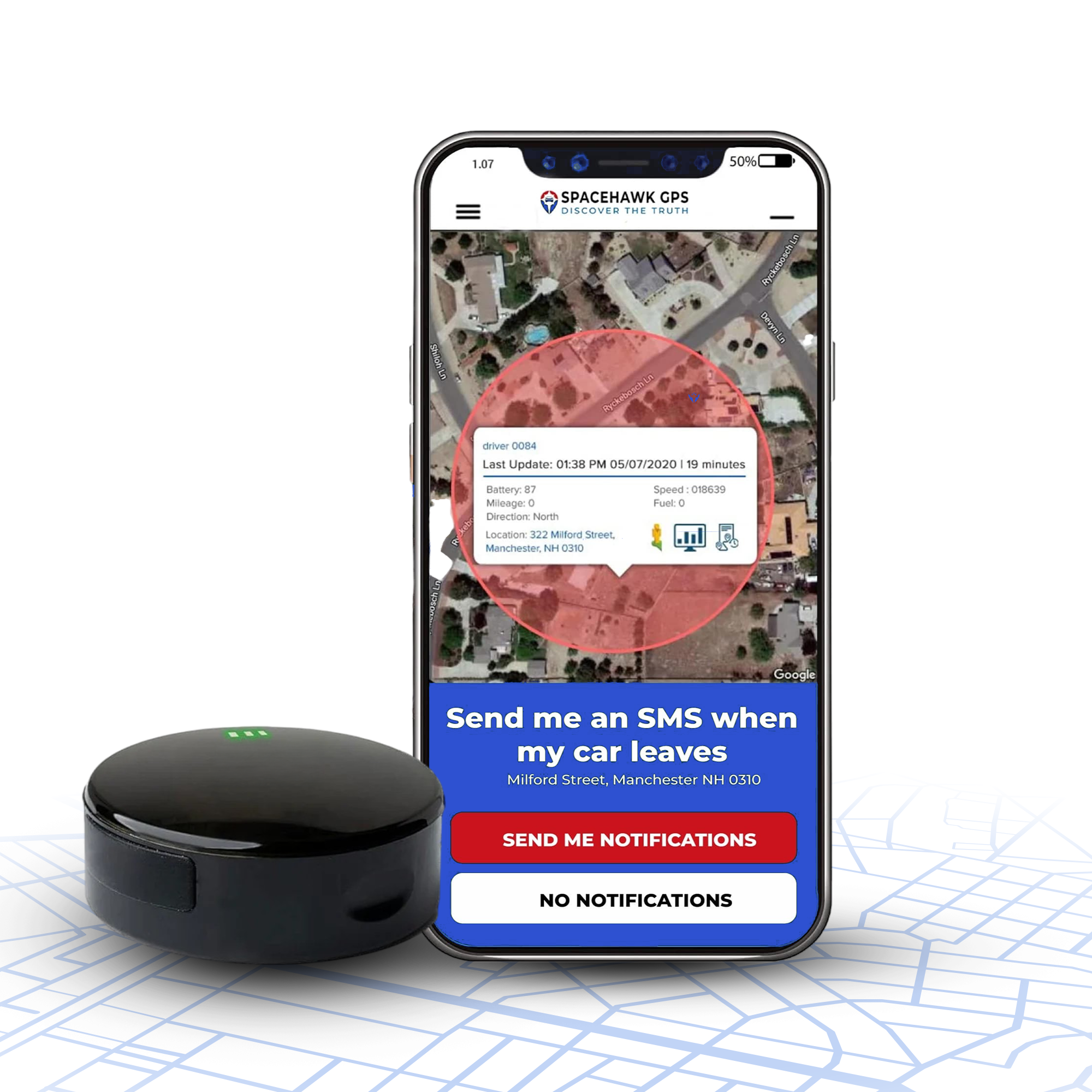
What Is Geofencing? How GPS Geofences & Alerts Work

Written by Ryan Horban
Founder & Owner, GPS Tracker Shop LLC

Key Takeaways
-
01
A geofence is a virtual boundary, and geofencing watches your tracker against it.
-
02
Alert speed follows the update interval, so a 60-second unit trails by a mile.
-
03
Draw fences wider than your property line, since phone GPS lands within 16 feet.
-
04
Turn on only the triggers you will act on, like entry, exit and after-hours.
-
05
Fence only vehicles you own or have permission to track, since state laws vary.
Know the moment something you own starts moving.
Shop GPS Trackers With Geofence AlertsGeofencing draws a virtual boundary around a real world location, then pings your phone the moment a tracked car, truck or trailer crosses that line. Simple idea but huge relief once you have one.
Without one, your trailer can roll out of a Murrieta storage lot at 2 a.m., and you’ll hear about it over coffee at 7.
I’m Ryan Horban, and closing that gap has been my job for 15+ years, with GPS trackers on fleets, job sites and family vehicles across Southern California. In this guide, I’ll show you what a geofence is and how geofencing technology checks location. You’ll also learn which alerts deserve a spot on your phone, why some show up late, and how to draw a fence that doesn’t cry wolf.
The basics come first.
DISCLOSURE: As an Amazon Associate, GPS Tracker Shop earns from qualifying purchases.
What Is a Geofence?
A geofence is a virtual boundary drawn around a real world geographic area, such as a driveway, job site or storage yard. Geofencing is the location based technology that watches location data against that line and fires an alert when a device enters or exits.

Below, I’ll pull the two terms apart, compare GPS tracking with geofencing marketing, and clear up what a geofence actually tracks.
The easiest way I explain one to customers is an invisible fence you draw with your finger on a phone map. No posts, no wire, no digging up the yard.
Geofence vs Geofencing
A geofence is the line itself, a digital boundary, while geofencing is everything that happens around the line.
The line lives in software as a shape. A circle uses a center point and a radius, and a polygon follows the actual shape of your lot with a string of latitude and longitude coordinates. Draw the shape once, name it something like Back Lot, and the fence sits over that physical location waiting.
Geofencing is the moving part of the deal. Your GPS tracker reports where the device is, the geofencing system compares that point against every one of your virtual perimeters, and the software sends a push notification, text or email when the device crosses.
The fence is the chalk line, and geofencing is the referee. The first time that whistle goes off on your phone, you’ll say wow.
GPS Tracking vs Geofencing Marketing Campaigns
GPS tracking records where a device goes all day, and a fence uses that location data to fire alerts at specific locations. Geofencing marketing borrows the same boundary idea for location based marketing, reaching shoppers with targeted advertisements.
Same chalk line, three very different jobs. A quick side-by-side keeps them straight.
| Comparison | GPS Tracking | GPS Geofencing | Geofencing Marketing |
|---|---|---|---|
| What It Watches | Every location update, all day | One defined boundary | Phones near a store or competitor locations |
| Device | GPS tracker | GPS tracker | Mobile devices with an app installed |
| What Fires | A trail of points and trip history | An entry, exit or dwell alert to you | An ad or push notification to the shopper |
| Built For | Seeing where something went | Knowing the moment something moves | Pulling potential customers through the door |
Marketing platforms run geofencing campaigns as a location based service inside mobile apps, so they need location permission from mobile users before anything fires. A retailer might draw a fence around its own parking lot, or around a rival’s lot a mile down the road, and offer a coupon to whoever wanders in. Clever, a little sneaky, and nothing like protecting your trailer.
For the rest of this guide, I’m sticking with the GPS tracker side.
What Geofencing Tracks and What It Doesn’t
Geofencing doesn’t track anything on its own, because a geofence is only a rule sitting on top of location data.

Location tracking has to come from somewhere else, and where those dots come from shapes what the fence can see. Phones and GPS trackers get their dots in very different ways, so three pieces do the work.
Notice what’s missing from that list. A tracker-based fence never sees who’s behind the wheel, what gets said in the cab or what’s on anyone’s phone. The fence simply watches whatever the tracker rides on, whether a Ford F-150, a utility trailer or a skid steer parked on a job site.
Serious note here. Privacy concerns and state law come into play once another person drives that vehicle, and I cover both near the end of this guide.
Up next is the fun part, how the system decides which side of the line your truck sits on.
How Geofencing Works (Step by Step)?
Three quick steps sit behind geofencing. The tracker finds its position, software compares that point against your fence, and the system triggers an alert when the point lands on the wrong side of the line.

I’ll walk through each step below, then cover where the software actually runs.
Geofencing Technology Starts With the Tracker
Geofencing technology starts with the global positioning system, and every tracker report follows the same short routine.
- Listens for GPS signals from at least four satellites.
- Works out its exact position on the map.
- Stamps that point with the date and time.
- Sends the point to a server over cellular data.
How often that routine repeats depends on the update interval. Hold that thought, because the interval decides how fast your alerts show up.
Update intervals run anywhere from every few seconds to every few minutes, and the underlying technology varies too. Phones lean on Wi-Fi and cell towers for a device’s general location, and some warehouse systems use radio frequency identification tags at the dock doors. For trucks, trailers and equipment out in the open, satellite GPS does the work.
Related guideHow Do GPS Trackers Work?My plain-English walkthrough of the satellite side, from signal lock to the dot on your map.See How Trackers WorkThe Server Compares the Point to the Fence
The software runs a simple yes-or-no check on every new point. Inside the fence or outside?
The software then compares that answer with the last point. An inside point followed by an outside point counts as an exit, and the reverse counts as an entry. Two matching answers in a row mean nothing changed, so your phone stays silent. Amazon’s own location service works the same way, keeping each device’s previous position so the system can tell an entry from an exit.
The Alert Hits Your Phone

Triggering alerts is the last step. The system fires whatever you set up the moment the software spots a crossing, sending notifications as a push alert, a text, an email or all three. Most apps also log the event with a time stamp, so you can scroll back later and see exactly when the trailer left the yard.
The whole loop runs in the background. You live your life, and the system watches the line.
Geofencing Software on a Server or the Device
Geofencing software runs in one of two places, and each spot comes with its own trade-off.
Server-side GPS based geofencing handles a trailer in a Temecula storage lot just fine. Either way, an alert only helps when you pick the right trigger, and those come next.
Geofence Alerts and Their Triggers
Four triggers drive almost every geofence alert, and the right one depends on what you’re protecting. Most tracking apps let you tie each fence to specific events, so a trailer lot and a job site can each get their own rules.

These are the four location based triggers I set up most for customers.
Exit alerts carry most of the load for theft. Pair one with an after-hours window, and a trailer leaving the yard at midnight on a Saturday gets your attention while the same trailer heading to a noon job stays silent. SpaceHawk handles that pairing with Alarm Mode, which schedules alerts for the time windows you set, and Konnect adds a tamper alert in case someone yanks the unit out of the OBD port.
Dwell alerts earn their keep on fleets, too. A service van parked at a customer site for four hours might mean a big job or an extra-long lunch, and the alert lets you ask before the invoice goes out.
One warning from experience, though.
Switch on every trigger for every fence, and your phone lights up so often you start swiping alerts away without reading them. Match each trigger to a real job instead, and the next section shows how fleets, job sites and families do exactly that.
Geofencing for Fleet Management and Asset Tracking
Fleet management and asset tracking get the most out of geofencing when every fence matches one real job, like guarding a yard, logging customer stops or watching a new driver. Below are the five setups I see most, then a closer look at job sites.

Each card names the trigger I’d pick and what you get out of it.
Numerous benefits stack up once the first fence proves itself, so start with one of these, live with it for a week, then add the next.
Asset Management on Job Sites
Asset management on job sites leans hard on boundary alerts, because equipment sits still for days and nobody watches it at night. A fence around the site does the watching for you.

This is the setup I recommend most to contractors around Riverside County. The trick is drawing the fence around the whole site, not just the spot where the excavator parked on Monday, since machines move around during the day. Pair the fence with an after-hours window that matches your crew’s schedule, and the only alerts you get are the ones worth a phone call.
The alert log adds valuable data, too, like which machines left the site and when.
For the hardware side, two trackers on GPS Tracker Shop cover most of these setups. SpaceHawk rides magnet-mounted on trailers and equipment, and Konnect plugs into a vehicle’s OBD port for cars, vans and teen drivers.

Fence the Yard. Hear About It First.
SpaceHawk rides magnet-mounted on trailers and equipment, with geofence and speed alerts by text and email.
 Buy on Amazon
Whichever tracker you pick, the fence you draw decides how useful those alerts feel, so the next step is drawing one the right way.
Drawing a Geofence That Works
Most apps let you create virtual boundaries in a few taps, but drawing a geofence that works comes down to three choices, the shape, the size and the triggers. Get those right on day one, and you’ll implement geofencing once instead of redrawing the fence every weekend.

Circle, Polygon and Route Fences
Radius based geofences are the quick option, and they suit most driveways.
You drop a center point, drag out the radius, and the app saves the circle as map coordinates. Polygons take a minute longer because you tap each corner. The payoff is a fence that follows the actual shape of a lot, so a long storage yard or an L-shaped job site doesn’t pick up half a block of empty street.
Fleets sometimes add route fences too, a skinny corridor that runs along a delivery road.
Sizing Rules That Stop False Alerts
Size causes more bad alerts than anything else I see. GPS-enabled phones typically land within 16 feet under open sky, according to GPS.gov, and a dedicated tracker like SpaceHawk sits around 6 feet in good conditions. Those margins grow near tall buildings, carports and trees, so a fence drawn right on the property line flips between inside and outside while your truck sits parked.
A few simple rules keep the fence honest.
- Draw the edge at least 100 feet past your property line.
- Keep your usual parking spot well inside the fence, never near the edge.
- Pick a polygon for long, skinny lots instead of one giant circle.
- Leave extra margin near tall buildings, carports and metal roofs.
- Name each fence plainly, like Back Lot or Job Site 14.
- Run the fence for a week, then tighten the edge if alerts stay clean.
Follow those, and your phone only speaks up when something actually moved.

Set Up a Geofence in Four Steps
Every tracker app labels things a little differently, but the setup follows the same path.
-
1
Open the Geofence Menu:
Open your tracker’s app and find the geofence or boundary menu.
-
2
Draw the Shape:
Drop a center point or tap the corners of your lot on the map.
-
3
Pick Your Triggers:
Pick entry, exit or both, plus any after-hours window you need.
-
4
Name, Save and Test:
Name and save the fence, then drive past the edge to test the alert.
Watch how long that test alert takes to land. A fast tracker usually alerts you before you reach the end of the street, while a slower unit might wait until you’re around the corner, and the next section explains why.
Why Geofence Alerts Arrive Late

Geofence alerts arrive late because a tracker only reports its position once per update interval, so the system can’t see a crossing until the next point comes in. The fence itself reacts in a blink. My guide to how real-time GPS trackers work digs into why those intervals differ so much between devices.
The math is simple, and a little scary.
88 feet per second
The distance a vehicle covers every second at 60 mph.
The blind spot between check-ins grows with every second of update interval.
Multiply that by the update interval, and you get the blind spot between check-ins. At 70 mph on the 15 between Murrieta and Temecula, a one-minute tracker covers more than a mile before the next point lands.
| Update Interval | Distance at 30 mph | Distance at 60 mph |
|---|---|---|
| Every 3 seconds | 132 feet | 264 feet |
| Every 30 seconds | 1,320 feet (quarter mile) | 2,640 feet (half mile) |
| Every 1 minute | Half a mile | 1 mile |
| Every 3 minutes | 1.5 miles | 3 miles |
Wow, right? At highway speed, a 3-minute plan lets a stolen trailer travel about three miles before the first exit alert can fire.
Battery trackers add one more wrinkle. SpaceHawk naps after about 2 minutes without motion to save battery, so a parked trailer that starts rolling needs a moment to wake up, grab a GPS fix and send that first point. Cell coverage and text delivery tack on a few more seconds, which is normal and nothing to panic about. My guide on whether a car tracker drains your battery covers those sleep modes in detail.
Buy the refresh rate first and draw the fence second. A one-minute tracker can be a mile down the 15 before your phone buzzes.
Ryan Horban, GPS Tracking Expert
SpaceHawk and Konnect both report as fast as every 3 seconds, and on SpaceHawk that speed comes from the plan you choose. Pick the faster tier for anything that sits outdoors overnight.

Plug In Once. Guard Every Trip.
Konnect plugs into the OBD2 port in seconds, with geofence and tamper alerts plus one year of trip history.
Speed is only one piece of the puzzle, and the numbers in the next section fill in the rest.
Geofencing Statistics Worth Knowing

The geofencing statistics below paint a simple picture, a tool that rides on almost every phone in the country and a market growing fast. These four numbers come from Pew Research, Google, Apple and Meticulous Research.
$12.7 billion
Projected global geofencing market by 2032, growing 23.6% a year.
Source: Meticulous Research
100 vs 20
Most geofences one app can watch at once on Android versus iPhone.
Source: Android Developers and Apple Core Location
20 seconds
How long an iPhone must stay past the boundary before an app hears about the crossing.
Source: Apple Core Location
Those phone numbers explain a lot. Apple tells developers to assume about 200 meters of travel past the line during testing, so phone geofences need a few hundred meters of slack. A GPS tracker skips that budget entirely, because the boundary check runs on the tracking company’s server, which lets a trailer fence stay much tighter than a phone geofence.
Tight still has limits, though, and GPS has a few quirks every owner should know.
Geofencing Accuracy and Limits
A fence can only be as sharp as the GPS fix and cell signal feeding it, so geofencing accuracy comes down to the location data underneath. Most days, that data is plenty sharp.

Four limits trip people up, and each one has a simple fix.
GPS Drift on a Parked Vehicle
A parked tracker’s position wanders a few feet as satellites move overhead, and a fence drawn too tight reads that wobble as an exit. Tracking platforms warn that small drift can trigger entry and exit alerts. Widen the fence, and the ghost alerts stop.
Dead Zones With No Cell Service
GPS works anywhere with open sky, but the alert needs a cell signal to reach you. Out in the backcountry past Anza, a tracker can know it crossed the line with no way to tell you. SpaceHawk stores those points and uploads them once it finds coverage, so your history fills in later.
Parking Garages and Metal Roofs
Groan. Concrete decks, metal roofs and dense urban environments block or bounce GPS signals, so the dot jumps around or freezes on the last good fix. A car parked three levels down in a mall garage might not report until it rolls back into daylight.
Old Fences and Faked Phones
A fence left around last year’s job site keeps firing whenever a truck drives past, so delete fences when the work ends. Phone-based geofences carry one more risk, since mock-location apps can fake a phone’s position, while a hardware tracker never relies on a phone.
None of these limits make a fence unreliable. A fence just works best with a little breathing room, a fast update interval and a quick cleanup every few months.
The last limit has nothing to do with satellites, and the legal side can land you in real trouble.
Geofencing Legal Rules and Privacy
Geofencing is legal when you geofence a vehicle or asset you own or have permission to track. Regulations vary once another person’s location gets involved, and the rules below cover the big ones.

Track Only What You Own
Track only vehicles and gear that belong to you, or ones you have clear permission to watch. Placing a tracker on someone else’s vehicle without consent is a crime in several states, including California and Texas.
Anyone worried about being tracked can call the National Domestic Violence Hotline at 1-800-799-7233 or visit stalkingawareness.org.
Owners and employers sit on the safe side when they do it right. California’s Penal Code 637.7 exempts a vehicle’s registered owner or lessee. New Jersey requires employers to give written notice before tracking any vehicle an employee drives, whether a company truck or a personal car. Put your policy in writing anyway, because a signed notice settles arguments before they start.
Phone-based fences get stricter treatment, since app data collection reaches people’s daily routines. California’s privacy law treats precise geolocation, a radius of 1,850 feet or less, as sensitive personal information. Washington goes further and bans geofences of 2,000 feet or less around in-person health care providers.
Geofence Warrants Are a Different Animal
In Chatrie v. United States, decided June 29, 2026, the Supreme Court held that a police geofence warrant for phone location data is a Fourth Amendment search. The Court sent the case back to decide whether that warrant was reasonable, and the ruling covers police requests to tech companies, not the fence around your trailer.
Laws shift, so run your state through the guide above before you track a shared vehicle. This is general information, not legal advice.
Final Thoughts: Draw Your First Geofence the Right Way
A good fence gives you an immediate response to the movement you care about, without staring at a map all day. Three moves get you there. Pick a tracker with a fast update interval, draw the fence wider than your property line, and switch on only the alerts you’ll actually act on.
Do that, and the next time your phone buzzes at 2 a.m., you’ll know the alert is worth getting out of bed for.
Draw Your First Geofence Today
GPS trackers with fast updates and geofence alerts by text and email.
Shop GPS TrackersDISCLOSURE: As an Amazon Associate, GPS Tracker Shop earns from qualifying purchases.
About the Author

Frequently Asked Questions
How much does geofencing cost?
Can a geofence stop or shut off a vehicle?
How can you tell if a geofence is tracking you?
Does geofencing drain a GPS tracker’s battery?
Can I set more than one geofence on a GPS tracker?
What is the difference between geofencing and geotargeting?
Does geofencing work outside the United States?
- Choosing a selection results in a full page refresh.
- Opens in a new window.